|
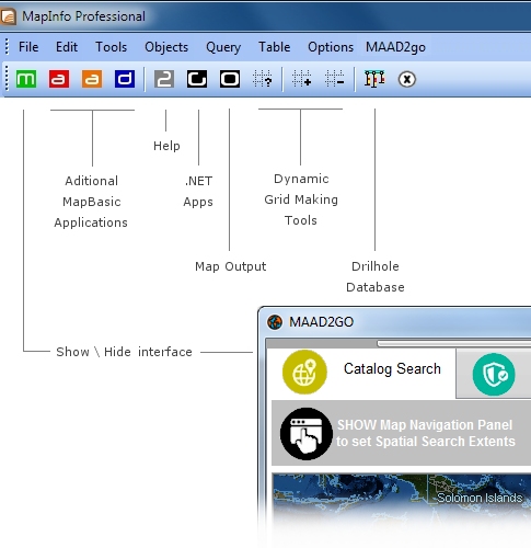
MAAD2GO has been designed with the popular GIS software (MapInfo Professional*) in mind.
Specially designed connectors exist that talk to MapBasic compiled scripts when MapInfo is operational.
In addition, a seperate toolbar and menu that contains alot of specific functionality created for MapInfo can be loaded into the MapInfo Professional interface (called maadgis.mbx).
This functionality has been built up over the years by MAAD Solutions in a program that used to be called MAADgis to make some of the tedious functionality of operating MapInfo easier and more intuitive.
This MAADgis functionality has been included within the MAAD2gO software as an added bonus for MapInfo Professional users, however this functionality is provided on an as-supplied basis and is not supported.
Functionality contained from these additional tools are listed below.
* MapInfo Professional is a trademark of Pitney Bowes Business Insight.
|
 |
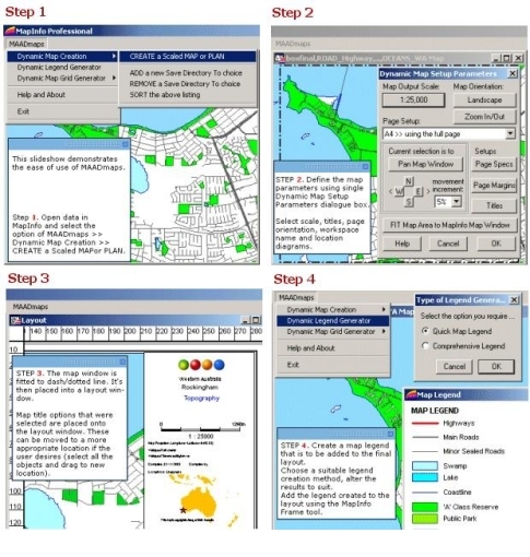 |
Turn your MapInfo layouts into a professional cartographic output.
This component provides the GIS User with the tools generate scaled maps and plans quickly and easily through a common interface.
Additional functionality enables the user to add scalebars, titles, and map production information to the resulting MapInfo layout.
Map production component includes;
- Dynamic scaled map generator.
- Legend generator.
- Dynamic grid generator.
|
|
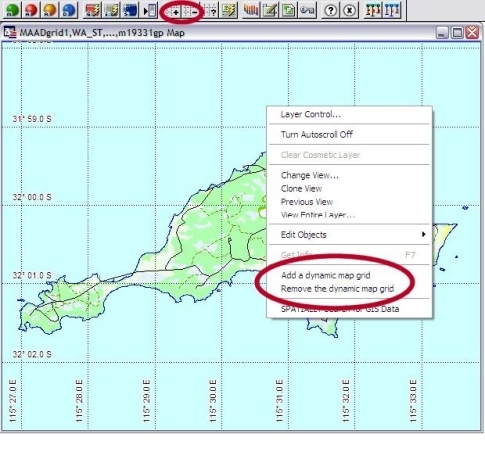
Dynamically Display Map Grid Lines, redraws automatically as you zoom in and out.
The method of placing a grid onto a map window has never been easier using this function.
MAADgis contains a dynamic map grid generator that creates a grid at a logical spacing within your specified map windows.
The Dynamic map Grid generator generates a grid that is dynamic, that is, if you pan, zoom in or out or resize the map window, the grid automatically redraws and updates itself.
This means that you do not have to re create a map grid every time a map window is altered, or save lots and lots of grid files.
|
 |
|
CAD Tools & Functions.
CAD components include;
- Break a Polyline into individual LINE Segments
- COLOUR Map Objects by a column in a table
- Connect the Points to form Shapes - polygons, polylines.
- Draw Line by a Bearing and distance
- Extract Nodes from Selected objects
- Select Objects by Graphical Styles
- Select Objects using Window Extents
- Reverse - Change Line Direction
|
Analysis Tools & Functions.
Analysis components include;
- CALCULATE bearing & distance between 2 points
- UPDATE entire table with Bearings and Distances
- LOCATE a point (by distance) along a polyline
- Proximity SEARCH - Locate surrounding objects
- ZOOM to a selected map object
|
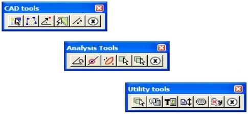 |
Table Utility Functions.
Utility components include;
- Combine ALL Map Layers into ONE table
- Create an EMPTY table shell from selected table
- Display a table's structure - Export to NotePad
- Export MapInfo Browser to HTML page
- Refresh ODBC Linked Tables
- String Text Search and Replace
- Sort a Table - Ascending,Descending
- View open Table Details - Projection,File Path,etc
- Update a Tables X and Y Coordinates
- Update Blank records in a column with the previous row's record
- UPDATE multiple Table(s) by multiple Column(s)
|
|
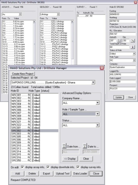
Simple Drillhole Database Manager.
The Drillhole Database Manager (codenamed: MAADdhole) is designed to provide the optimal solution to store and maintain drilling and sampling data within a mineral exploration environment.
MAADdhole achieves this by providing the tools to easily access, display and maintain your drilling and sampling data through the MapInfo GIS environment, interacting with cleverly designed database backend.
Benefits
- Inexpensive alternative to other high priced drill-hole databases.
- Integrates seamlessly into MAADgis and MapInfo environment.
- In-built Validation routines for new and existing data, including the tracking of changed data.
- Easy and Intuitive interfaces to manage database information.
- Correctly displays collar, survey traces and projected assay locations.
- Exports data that can be readily used in other applications.
Features - At A Glance
- Maintains drillhole data residing in an external database through intuitive interfaces within the MapInfo environment, or as a standalone program.
- Validation routines automatically provided for adding or altering data (i.e. duplicate checking).
- QA linking function matches assay data to lab methods.
- Exports data in flat file format within MapInfo, compatible with other 3rd party geological modelling programs.
- Bulk or individual upload function provided, with duplicate checking.
- Advanced display, query and export functionality.
- Spatially displays collars, survey trace and projected assay data.
- Simple to understand database structure.
- Integrates into MAADgis for rich cataloguing functionality and display.
- Centrally store and retrieve review data for evaluation.
|
 |